
Make a donation
Gear up for your next adventure:
As an Amazon Associate, this site earns from qualifying purchases at no extra cost to you.
Sa Pa topographic map
Click on the map to display elevation.
Make a donation
Gear up for your next adventure:
As an Amazon Associate, this site earns from qualifying purchases at no extra cost to you.
Sa Pa
Sa Pa District is in Lào Cai Province, northwest Vietnam, 380 km northwest of Hanoi close to the border with China. The Hoàng Liên Son range of mountains dominates the district, which is at the eastern extremity of the Himalayas. This range includes Vietnam's highest mountain, Fan Si Pan, at a height of 3143 m above sea level. In addition, other mountains like Aurora & J (where the sun appears at sunrise) complete a very steep terrain. The town of Sa Pa lies at an elevation of about 1500 meters (4,921 feet) elevation. The climate is moderate and rainy in summer (May—August), and foggy and cold with occasional snowfalls in winter.
Make a donation
Gear up for your next adventure:
As an Amazon Associate, this site earns from qualifying purchases at no extra cost to you.
About this map
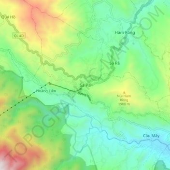
Name: Sa Pa topographic map, elevation, terrain.
Location: Sa Pa, Lào Cai Province, 33000, Vietnam (22.29592 103.80267 22.37592 103.88267)
Average elevation: 1,520 m
Minimum elevation: 979 m
Maximum elevation: 2,720 m
Make a donation
Gear up for your next adventure:
As an Amazon Associate, this site earns from qualifying purchases at no extra cost to you.
Other topographic maps
Click on a map to view its topography, its elevation and its terrain.