Geolocate

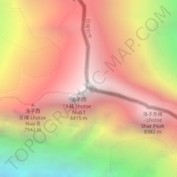
Lhotse topographic map

Click on the map to display elevation.

Lhotse

Lhotse (Nepali: ल्होत्से, romanized: L'hōtsē [lotse]; Standard Tibetan: ལྷོ་རྩེ, romanized: lho tse, lit. 'South Peak' [l̥otse]; Chinese: 洛子峰) is the fourth-highest mountain on Earth, after Mount Everest, K2, and Kangchenjunga. At an elevation of 8,516 metres (27,940 ft) above sea level, the main summit is on the border between the Tibet Autonomous Region of China and the Khumbu region of Nepal.

Wikipedia (CC-BY-SA 3.0)

About this map

Name: Lhotse topographic map, elevation, terrain.

Location: Lhotse, Khumbupasanglahmu, Solukhumbu, Koshi Province, Nepal (27.96194 86.93245 27.96204 86.93255)

Average elevation: 7,391 m

Minimum elevation: 5,780 m

Maximum elevation: 8,499 m

Other topographic maps

Click on a map to view its topography, its elevation and its terrain.
Khumbupasanglahmu

Nepal > Koshi Province > Solukhumbu

Average elevation: 4,909 m

Sotang

Nepal > Koshi Province > Solukhumbu

Average elevation: 2,173 m

Likhupike

Nepal > Koshi Province > Solukhumbu

Average elevation: 2,755 m

West Ridge

Nepal > Koshi Province > Solukhumbu

Average elevation: 7,035 m

Khumbupasanglahmu-05

Nepal > Koshi Province > Solukhumbu

Average elevation: 5,232 m

Gear up for your next adventure:

🧼Technical Clothing Wash - Special soap to clean and restore waterproof membranes
🧵Survival Paracord - Multi-purpose cordage for emergency repairs and shelters
🧘Folding Sit Mats - Dry and warm seat for map-reading breaks on damp ground
🧢Thermal Beanie Hats - Prevent heat loss from the head in windy summit conditions
🎒Hiking Child Carriers - Explore the outdoors with the whole family safely

As an Amazon Associate, this site earns from qualifying purchases at no extra cost to you.