
Warminster topographic map
Click on the map to display elevation.
Warminster
Warminster Town Hall, at the junction of the High Street and Weymouth Street, was designed c. 1837 by Edward Blore at the expense of the 5th Marquess of Bath; the two-storey front elevation is a replica of Longleat, with the addition of a central bellcote, clock and coat of arms. The building was sold by the district council in 1979.
About this map
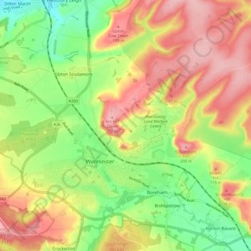
Name: Warminster topographic map, elevation, terrain.
Location: Warminster, Wiltshire, England, United Kingdom (51.18948 -2.22830 51.24075 -2.11980)
Average elevation: 143 m
Minimum elevation: 70 m
Maximum elevation: 215 m
Wiltshire trails, hiking, mountain biking, running and outdoor activities
Other topographic maps
Click on a map to view its topography, its elevation and its terrain.
Cley Hill
United Kingdom > England > Wiltshire
Cley Hill (grid reference ST838449) is a prominent hill to the west of Warminster in Wiltshire, England. Its summit has a commanding view of the Wiltshire / Somerset county boundary, at 244 metres (801 ft) elevation. The land is in Corsley parish and is owned by the National Trust.
Average elevation: 157 m