Geolocate

Satari topographic map

Click on the map to display elevation.

About this map

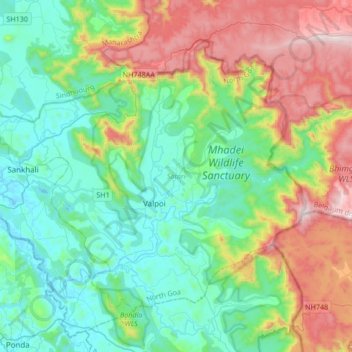
Name: Satari topographic map, elevation, terrain.

Location: Satari, North Goa, Goa, India (15.43064 73.94537 15.68233 74.28236)

Average elevation: 297 m

Minimum elevation: -2 m

Maximum elevation: 1,017 m

Other topographic maps

Click on a map to view its topography, its elevation and its terrain.

Surla

India > Goa > Satari > Nanorem

Average elevation: 384 m

Gear up for your next adventure:

🧭GPS Trackers - Tracking devices for safety and navigation
🧭Orienteering Compasses - Accurate compasses for map-based navigation
🕶️Glacier Goggles - Maximum protection for high-altitude snow topography
🧰First Aid Kits - Essential safety kits for outdoor activities
🧭Emergency Beacons - Safety beacons for remote outdoor locations

As an Amazon Associate, this site earns from qualifying purchases at no extra cost to you.