
Lake County topographic map
Interactive map
Click on the map to display elevation.
About this map
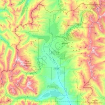
Name: Lake County topographic map, elevation, terrain.
Location: Lake County, Colorado, United States (39.05652 -106.58674 39.38371 -106.13586)
Average elevation: 3,398 m
Minimum elevation: 2,739 m
Maximum elevation: 4,388 m
Lake County is one of 64 counties in the U.S. state of Colorado. As of the 2010 census, the population was 7,310. The county seat and the only municipality in the county is Leadville. The highest natural point in Colorado and the entire Rocky Mountains is the summit of Mount Elbert in Lake County at 14,440 feet (4401.2 meters) elevation.
Other topographic maps
Click on a map to view its topography, its elevation and its terrain.
Mount Sherman
United States > Colorado > Lake County
Mount Sherman, Lake County, Colorado, United States
Average elevation: 3,989 m
Leadville
United States > Colorado > Lake County
Leadville, Lake County, Colorado, 80461, United States
Average elevation: 3,106 m
Leadville
United States > Colorado > Lake County
Leadville, Lake County, Colorado, 80461, United States
Average elevation: 3,106 m
Mount Elbert
United States > Colorado > Lake County
Mount Elbert, Lake County, Colorado, United States
Average elevation: 3,958 m