
Make a donation
Gear up for your next adventure:
As an Amazon Associate, this site earns from qualifying purchases at no extra cost to you.
Oerlenbach topographic map
Click on the map to display elevation.
Make a donation
Gear up for your next adventure:
As an Amazon Associate, this site earns from qualifying purchases at no extra cost to you.
About this map
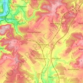
Name: Oerlenbach topographic map, elevation, terrain.
Location: Oerlenbach, Landkreis Bad Kissingen, Bavaria, 97714, Germany (50.10349 10.08973 50.19110 10.18031)
Average elevation: 321 m
Minimum elevation: 195 m
Maximum elevation: 402 m
Make a donation
Gear up for your next adventure:
As an Amazon Associate, this site earns from qualifying purchases at no extra cost to you.
Other topographic maps
Click on a map to view its topography, its elevation and its terrain.
Hammelburg
Germany > Bavaria > Landkreis Bad Kissingen > Hammelburg > Hammelburg
Average elevation: 260 m
Make a donation
Gear up for your next adventure:
As an Amazon Associate, this site earns from qualifying purchases at no extra cost to you.
Bad Kissingen
Germany > Bavaria > Landkreis Bad Kissingen > Bad Kissingen > Bad Kissingen
Average elevation: 295 m