
Make a donation
Gear up for your next adventure:
As an Amazon Associate, this site earns from qualifying purchases at no extra cost to you.
Pantón topographic map
Click on the map to display elevation.
Make a donation
Gear up for your next adventure:
As an Amazon Associate, this site earns from qualifying purchases at no extra cost to you.
Pantón
El relieve del término municipal de Pantón está caracterizado por las depresiones de los ríos Cabe, Miño y Sil, entre las que se alzan los Montes de San Paio, que alcanzan los 686 metros de altitud. La mayor altura del territorio es el monte Pena Pombeira (703 metros), situado al sur, cerca del cañón del Sil, que hace de frontera natural con la provincia de Orense.
Make a donation
Gear up for your next adventure:
As an Amazon Associate, this site earns from qualifying purchases at no extra cost to you.
About this map
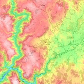
Name: Pantón topographic map, elevation, terrain.
Location: Pantón, Tierra de Lemos, Lugo, Galicia, España (42.42174 -7.73110 42.59594 -7.55359)
Average elevation: 444 m
Minimum elevation: 108 m
Maximum elevation: 728 m
Make a donation
Gear up for your next adventure:
As an Amazon Associate, this site earns from qualifying purchases at no extra cost to you.
Other topographic maps
Click on a map to view its topography, its elevation and its terrain.
Make a donation
Gear up for your next adventure:
As an Amazon Associate, this site earns from qualifying purchases at no extra cost to you.
Make a donation
Gear up for your next adventure:
As an Amazon Associate, this site earns from qualifying purchases at no extra cost to you.
Make a donation
Gear up for your next adventure:
As an Amazon Associate, this site earns from qualifying purchases at no extra cost to you.
Make a donation
Gear up for your next adventure:
As an Amazon Associate, this site earns from qualifying purchases at no extra cost to you.
Pacios de Veiga
España > Galicia > Tierra de Lemos > A Pobra do Brollón > Pacios de Veiga
Average elevation: 469 m
Make a donation
Gear up for your next adventure:
As an Amazon Associate, this site earns from qualifying purchases at no extra cost to you.
Make a donation
Gear up for your next adventure:
As an Amazon Associate, this site earns from qualifying purchases at no extra cost to you.