
Thank you for supporting this site ❤️
Make a donation
Make a donation
Gear up for your next adventure:
As an Amazon Associate, this site earns from qualifying purchases at no extra cost to you.
Maragoli topographic map
Click on the map to display elevation.
Thank you for supporting this site ❤️
Make a donation
Make a donation
Gear up for your next adventure:
As an Amazon Associate, this site earns from qualifying purchases at no extra cost to you.
About this map
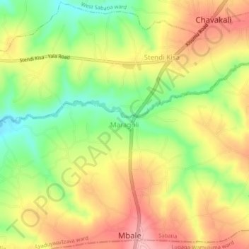
Name: Maragoli topographic map, elevation, terrain.
Location: Maragoli, Lyaduywa/Izava ward, Sabatia, Vihiga County, Kenya (0.08133 34.69949 0.12133 34.73949)
Average elevation: 1,561 m
Minimum elevation: 1,486 m
Maximum elevation: 1,629 m
Thank you for supporting this site ❤️
Make a donation
Make a donation
Gear up for your next adventure:
As an Amazon Associate, this site earns from qualifying purchases at no extra cost to you.