
Mpraeso topographic map
Interactive map
Click on the map to display elevation.
About this map
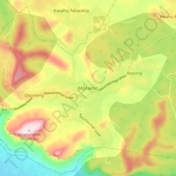
Name: Mpraeso topographic map, elevation, terrain.
Location: Mpraeso, Kwahu South District, Eastern Region, Ghana (6.55661 -0.77339 6.63661 -0.69339)
Average elevation: 486 m
Minimum elevation: 225 m
Maximum elevation: 768 m
Mpraeso is a town and the capital of Kwahu South district, a district in the Eastern Region of south Ghana, located at an altitude of 367 m on the Kwahu Plateau, which forms the south-west boundary of Lake Volta. Mpraeso has a 2013 settlement population of 11,190 people.