
Thank you for supporting this site ❤️
Make a donation
Make a donation
Gear up for your next adventure:
As an Amazon Associate, this site earns from qualifying purchases at no extra cost to you.
Tashigang topographic map
Click on the map to display elevation.
Thank you for supporting this site ❤️
Make a donation
Make a donation
Gear up for your next adventure:
As an Amazon Associate, this site earns from qualifying purchases at no extra cost to you.
About this map
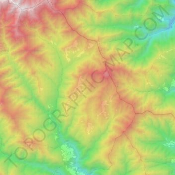
Name: Tashigang topographic map, elevation, terrain.
Location: Tashigang, Tseza Gewog, Dagana District, Bhutan (27.07718 89.79956 27.27706 89.94919)
Average elevation: 2,345 m
Minimum elevation: 1,037 m
Maximum elevation: 4,030 m
Thank you for supporting this site ❤️
Make a donation
Make a donation
Gear up for your next adventure:
As an Amazon Associate, this site earns from qualifying purchases at no extra cost to you.