
Eskilstuna kommun topographic map
Interactive map
Click on the map to display elevation.
About this map
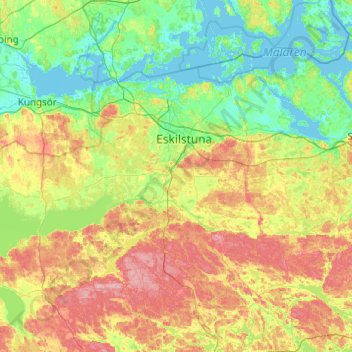
Name: Eskilstuna kommun topographic map, elevation, terrain.
Location: Eskilstuna kommun, Comté de Södermanland, Suède (59.14529 15.86465 59.49228 16.84736)
Average elevation: 34 m
Minimum elevation: -2 m
Maximum elevation: 106 m
Other topographic maps
Click on a map to view its topography, its elevation and its terrain.
Katrineholms kommun
Katrineholms kommun, Comté de Södermanland, Suède
Average elevation: 52 m
Trosa kommun
Trosa kommun, Comté de Södermanland, Suède
Average elevation: 10 m
Nyköping
Nyköping, Nyköpings kommun, Comté de Södermanland, 611 33, Suède
Average elevation: 19 m