
Mostaganem topographic map
Interactive map
Click on the map to display elevation.
About this map
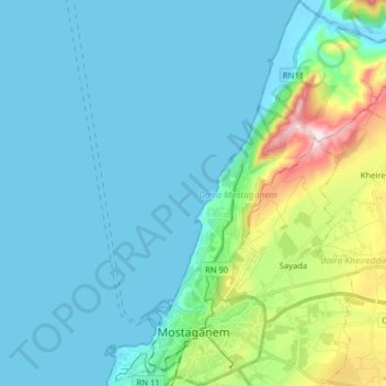
Name: Mostaganem topographic map, elevation, terrain.
Location: Mostaganem, Mostaganem district, Mostaganem, 27000, Algeria (35.91067 0.05362 36.03876 0.17673)
Average elevation: 68 m
Minimum elevation: -2 m
Maximum elevation: 399 m
Other topographic maps
Click on a map to view its topography, its elevation and its terrain.
Mostaganem
Algeria > Mostaganem > Mostaganem
Mostaganem, Mostaganem district, Mostaganem, 27000, Algeria
Average elevation: 86 m