
Amantani topographic map
Interactive map
Click on the map to display elevation.
About this map
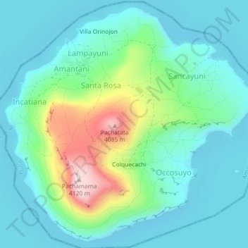
Name: Amantani topographic map, elevation, terrain.
Location: Amantani, Amantaní, Provincia de Puno, Puno, Perú (-15.68095 -69.72773 -15.64877 -69.69236)
Average elevation: 3,881 m
Minimum elevation: 3,805 m
Maximum elevation: 4,135 m
Other topographic maps
Click on a map to view its topography, its elevation and its terrain.