
Halchita topographic map
Click on the map to display elevation.
About this map
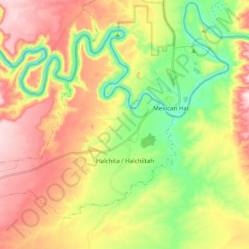
Name: Halchita topographic map, elevation, terrain.
Location: Halchita, San Juan County, Utah, United States (37.09912 -109.99793 37.18280 -109.85895)
Average elevation: 1,398 m
Minimum elevation: 1,210 m
Maximum elevation: 1,616 m
Other topographic maps
Click on a map to view its topography, its elevation and its terrain.
Colorado Plateau
United States > Utah > San Juan County
Younger igneous rocks form spectacular topographic features. The Henry Mountains, La Sal Range, and Abajo Mountains, ranges that dominate many views in southeastern Utah, are formed about igneous rocks that were intruded in the interval from 20 to 31 million years: some igneous intrusions in these mountains…
Average elevation: 1,512 m
Sentinel Mesa
United States > Utah > San Juan County
Monument Valley is part of the Colorado Plateau. The elevation of the valley floor ranges from 5,000 to 6,000 feet (1,500 to 1,800 m) above sea level. The floor is largely siltstone of the Cutler Group, or sand derived from it, deposited by the meandering rivers that carved the valley. The valley's vivid red…
Average elevation: 1,683 m
Colorado Plateau
United States > Utah > San Juan County
Younger igneous rocks form spectacular topographic features. The Henry Mountains, La Sal Range, and Abajo Mountains, ranges that dominate many views in southeastern Utah, are formed about igneous rocks that were intruded in the interval from 20 to 31 million years: some igneous intrusions in these mountains…
Average elevation: 1,512 m