
Thank you for supporting this site ❤️
Make a donation
Make a donation
Gear up for your next adventure:
As an Amazon Associate, this site earns from qualifying purchases at no extra cost to you.
Leticia topographic map
Click on the map to display elevation.
Thank you for supporting this site ❤️
Make a donation
Make a donation
Gear up for your next adventure:
As an Amazon Associate, this site earns from qualifying purchases at no extra cost to you.
About this map
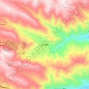
Name: Leticia topographic map, elevation, terrain.
Location: Leticia, La Unión, Tarma, Junín, Perú (-11.41730 -75.79194 -11.33730 -75.71194)
Average elevation: 3,809 m
Minimum elevation: 3,089 m
Maximum elevation: 4,271 m
Thank you for supporting this site ❤️
Make a donation
Make a donation
Gear up for your next adventure:
As an Amazon Associate, this site earns from qualifying purchases at no extra cost to you.