
El Tambo topographic map
Interactive map
Click on the map to display elevation.
About this map
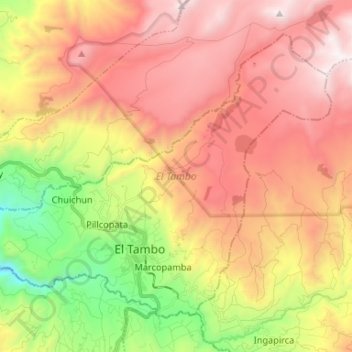
Name: El Tambo topographic map, elevation, terrain.
Location: El Tambo, Cañar, Ecuador (-2.53583 -78.98693 -2.42969 -78.85521)
Average elevation: 3,453 m
Minimum elevation: 2,489 m
Maximum elevation: 4,295 m
Other topographic maps
Click on a map to view its topography, its elevation and its terrain.
La Puntilla
Ecuador > Cañar > La Troncal
La Puntilla, Pancho Negro, La Troncal, Cañar, 030450, Ecuador
Average elevation: 70 m
San Antonio
Ecuador > Cañar > Cañar > San Antonio
San Antonio, Cañar, Ecuador
Average elevation: 2,772 m