
Huyện Cẩm Mỹ topographic map
Interactive map
Click on the map to display elevation.
About this map
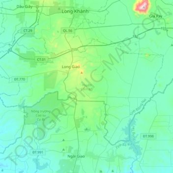
Name: Huyện Cẩm Mỹ topographic map, elevation, terrain.
Location: Huyện Cẩm Mỹ, Tỉnh Đồng Nai, Viêt Nam (10.66852 107.07173 10.89949 107.41966)
Average elevation: 132 m
Minimum elevation: 18 m
Maximum elevation: 820 m
Other topographic maps
Click on a map to view its topography, its elevation and its terrain.
Parc national de Cat Tien
Viêt Nam > Tỉnh Đồng Nai > Huyện Tân Phú
Parc national de Cat Tien, Huyện Tân Phú, Tỉnh Đồng Nai, Viêt Nam
Average elevation: 243 m
Thị trấn Long Giao
Viêt Nam > Tỉnh Đồng Nai > Huyện Cẩm Mỹ > Thị trấn Long Giao
Thị trấn Long Giao, Huyện Cẩm Mỹ, Tỉnh Đồng Nai, Viêt Nam
Average elevation: 231 m