
Newton topographic map
Interactive map
Click on the map to display elevation.
About this map
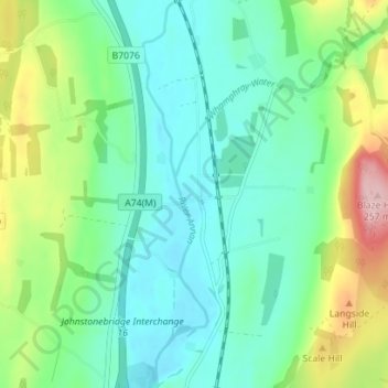
Name: Newton topographic map, elevation, terrain.
Average elevation: 117 m
Minimum elevation: 63 m
Maximum elevation: 261 m
Other topographic maps
Click on a map to view its topography, its elevation and its terrain.
Kirkton
United Kingdom > Scotland > Dumfries and Galloway
Kirkton, Dumfries and Galloway, Scotland, DG1 1WD, United Kingdom
Average elevation: 24 m
Beattock
United Kingdom > Scotland > Dumfries and Galloway
Beattock, Dumfries and Galloway, Scotland, DG10 9RB, United Kingdom
Average elevation: 144 m
Calfield
United Kingdom > Scotland > Dumfries and Galloway > Langholm > Becks
Calfield, Becks, Langholm, Dumfries and Galloway, Scotland, DG13 0LP, United Kingdom
Average elevation: 204 m
Closeburn
United Kingdom > Scotland > Dumfries and Galloway
Closeburn, Dumfries and Galloway, Scotland, DG3 5HT, United Kingdom
Average elevation: 81 m