Geolocate

Samal topographic map

Click on the map to display elevation.

About this map

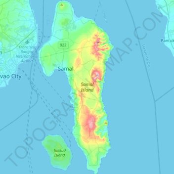
Name: Samal topographic map, elevation, terrain.

Location: Samal, Davao del Norte, Davao Region, Philippines (6.89257 125.66342 7.19811 125.79798)

Average elevation: 35 m

Minimum elevation: -1 m

Maximum elevation: 496 m

Other topographic maps

Click on a map to view its topography, its elevation and its terrain.

San Miguel

Philippines > Davao del Norte > Sawata

Average elevation: 84 m

Upper Tagasan

Philippines > Davao del Norte > Kapalong > Gupitan

Average elevation: 154 m

Maniki

Philippines > Davao del Norte > Kapalong

Average elevation: 22 m

Canocotan

Philippines > Davao del Norte

Average elevation: 9 m

San Roque

Philippines > Davao del Norte > Panabo

Average elevation: 132 m

Tagum

Philippines > Davao del Norte > Tagum

One of the significant accomplishments of the officialdom of Tagum during the 1990s was its elevation from a second to the first-class municipality. This opened a gateway to increase its financial resources through the Internal Revenue Allocation (IRA) from the national government and local revenues.

Average elevation: 103 m

Samal

Philippines > Davao del Norte > Samal > Samal

Average elevation: 38 m

Magdum

Philippines > Davao del Norte

Average elevation: 39 m

Gear up for your next adventure:

🖼️Topographic Map Art - Decorative 3D-effect posters of famous UK peaks and regions
🗺️Topographic Maps - Detailed maps showing elevation and terrain features
🧼Technical Clothing Wash - Special soap to clean and restore waterproof membranes
👖Hiking Trousers - Durable trousers designed for rough terrain
👖Packable Overtrousers - Quick-deploy rain protection for legs in sudden storms

As an Amazon Associate, this site earns from qualifying purchases at no extra cost to you.