Geolocate

Magdum topographic map

Click on the map to display elevation.

About this map

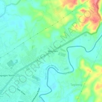
Name: Magdum topographic map, elevation, terrain.

Location: Magdum, Davao del Norte, Davao Region, 8100, Philippines (7.44922 125.81402 7.48922 125.85402)

Average elevation: 39 m

Minimum elevation: 16 m

Maximum elevation: 101 m

Other topographic maps

Click on a map to view its topography, its elevation and its terrain.

Panaga River

Philippines > Davao del Norte

Average elevation: 266 m

Kapalong

Philippines > Davao del Norte

Average elevation: 225 m

Samal

Philippines > Davao del Norte

Average elevation: 35 m

Carmen

Philippines > Davao del Norte > Carmen

Average elevation: 16 m

Gear up for your next adventure:

🎒Multi-day Trekking Packs - Large capacity backpacks for wild camping and long-distance trails
🔦Waterproof LED Headlamps - Hands-free lighting for evening treks and emergency navigation
🔦LED Camping Lanterns - Illumination for reading maps inside your tent at night
🛰️Outdoor GPS Navigation - Navigation devices for remote and off-grid areas
🧵Survival Paracord - Multi-purpose cordage for emergency repairs and shelters

As an Amazon Associate, this site earns from qualifying purchases at no extra cost to you.