
Westelijke Leie topographic map
Interactive map
Click on the map to display elevation.
About this map
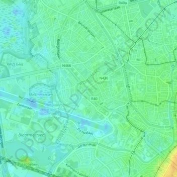
Name: Westelijke Leie topographic map, elevation, terrain.
Location: Westelijke Leie, Gent, Oost-Vlaanderen, Vlaanderen, 9000, België (51.05044 3.69746 51.05722 3.70787)
Average elevation: 8 m
Minimum elevation: -13 m
Maximum elevation: 30 m
Other topographic maps
Click on a map to view its topography, its elevation and its terrain.
Zwijnaarde
België > Oost-Vlaanderen > Gent > Gent
Zwijnaarde, Gent, Oost-Vlaanderen, Vlaanderen, 9052, België
Average elevation: 9 m
Sint-Amandsberg
België > Oost-Vlaanderen > Gent > Gent
Sint-Amandsberg, Gent, Oost-Vlaanderen, Vlaanderen, 9040, België
Average elevation: 8 m
Gent
België > Oost-Vlaanderen > Gent > Gent
Gent, Oost-Vlaanderen, Vlaanderen, 24-32, België
Average elevation: 12 m
Drongen
België > Oost-Vlaanderen > Gent > Gent
Drongen, Gent, Oost-Vlaanderen, Vlaanderen, 9031, België
Average elevation: 7 m
Groenzone Scandinaviëstraat
België > Oost-Vlaanderen > Gent > Gent
Groenzone Scandinaviëstraat, Muide, Gent, Oost-Vlaanderen, Vlaanderen, België
Average elevation: 8 m
Mariakerke
België > Oost-Vlaanderen > Gent > Gent
Mariakerke, Gent, Oost-Vlaanderen, 9030, België
Average elevation: 7 m