
Thank you for supporting this site ❤️
Make a donation
Make a donation
Gear up for your next adventure:
As an Amazon Associate, this site earns from qualifying purchases at no extra cost to you.
Sondershausen topographic map
Click on the map to display elevation.
Thank you for supporting this site ❤️
Make a donation
Make a donation
Gear up for your next adventure:
As an Amazon Associate, this site earns from qualifying purchases at no extra cost to you.
About this map
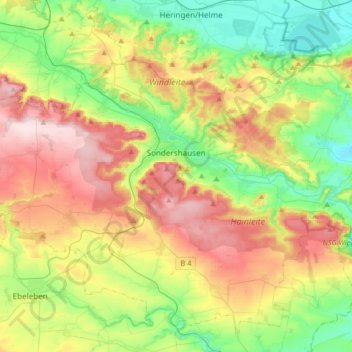
Name: Sondershausen topographic map, elevation, terrain.
Location: Sondershausen, Kyffhäuserkreis, Thuringia, 99706, Germany (51.28352 10.62026 51.42166 10.94949)
Average elevation: 273 m
Minimum elevation: 144 m
Maximum elevation: 464 m
Thank you for supporting this site ❤️
Make a donation
Make a donation
Gear up for your next adventure:
As an Amazon Associate, this site earns from qualifying purchases at no extra cost to you.
Other topographic maps
Click on a map to view its topography, its elevation and its terrain.
Unterburg
Germany > Thuringia > Kyffhäuserkreis > Kyffhäuserland > Kohlstätte
Average elevation: 301 m