Geolocate

Gumpang topographic map

Click on the map to display elevation.

About this map
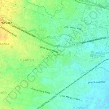
Name: Gumpang topographic map, elevation, terrain.

Location: Gumpang, Sukoharjo, Central Java, 57162, Indonesia (-7.58375 110.73916 -7.54375 110.77916)

Average elevation: 113 m

Minimum elevation: 102 m

Maximum elevation: 129 m

Other topographic maps

Click on a map to view its topography, its elevation and its terrain.
Lapangan Makamhaji

Indonesia > Central Java > Sukoharjo > Gentan > Kuyudan

Average elevation: 104 m

Tangkisan

Indonesia > Central Java > Sukoharjo

Average elevation: 98 m

Gear up for your next adventure:

🐕Hiking Dog Harnesses - Rugged harnesses for taking your companion on mountain trails
🥤Hiking Water Bottles - Reusable bottles for hydration on the trail
🎒Hiking Backpacks - Comfortable backpacks for day hikes and multi-day treks
🧤Waterproof Overmitts - Extreme weather protection for hikers and mountaineers
🍳Camping Stoves - Compact stoves for outdoor cooking

As an Amazon Associate, this site earns from qualifying purchases at no extra cost to you.