
Anthem topographic map
Click on the map to display elevation.
Anthem
Anthem is built on 5,856 acres (9.2 sq mi) at the base of Daisy Mountain and Gavilan Peak in northern Maricopa County. The CDP portion of Anthem has an area of 7.9 square miles (20 km2). The community's elevation ranges from 1,760 to 2,428 feet (536 to 740 m), with an average elevation of 1,863 feet (568 m). Approximately 36 percent of the community is preserved as open space, including 291 acres (118 ha) of open hillside.
About this map
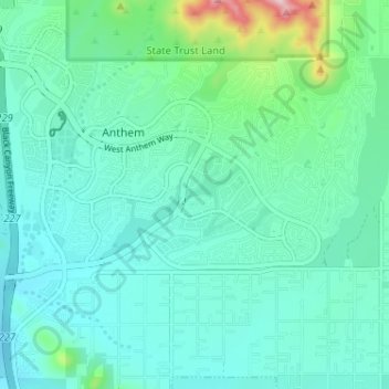
Name: Anthem topographic map, elevation, terrain.
Location: Anthem, Maricopa County, Arizona, United States (33.82719 -112.14685 33.87839 -112.08250)
Average elevation: 580 m
Minimum elevation: 521 m
Maximum elevation: 856 m