Geolocate

Stilfontein topographic map

Click on the map to display elevation.

About this map

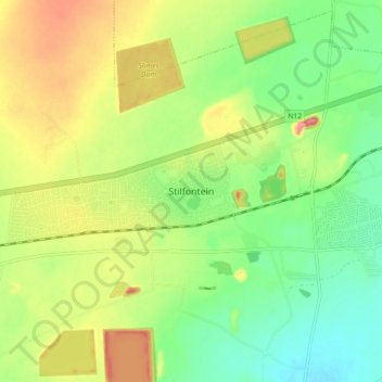
Name: Stilfontein topographic map, elevation, terrain.

Location: Stilfontein, Matlosana Local Municipality, Dr Kenneth Kaunda District Municipality, North West, 2551, South Africa (-26.88299 26.74325 -26.80299 26.82325)

Average elevation: 1,346 m

Minimum elevation: 1,303 m

Maximum elevation: 1,405 m

Other topographic maps

Click on a map to view its topography, its elevation and its terrain.

Gear up for your next adventure:

🌄Compact Monoculars - Lightweight optics for hiking
🔦Keychain LED Torches - Emergency backup light for finding gear in your pack
Lightweight Tents - Compact tents for backpacking and trekking
🧵Survival Paracord - Multi-purpose cordage for emergency repairs and shelters
🧦Hiking Socks - Breathable socks designed to prevent blisters on long walks

As an Amazon Associate, this site earns from qualifying purchases at no extra cost to you.