
Richland topographic map
Interactive map
Click on the map to display elevation.
About this map
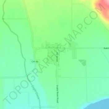
Name: Richland topographic map, elevation, terrain.
Location: Richland, Baker County, Oregon, United States (44.76485 -117.17220 44.77038 -117.16524)
Average elevation: 669 m
Minimum elevation: 627 m
Maximum elevation: 766 m
Other topographic maps
Click on a map to view its topography, its elevation and its terrain.
Baker City
United States > Oregon > Baker County
Baker City, Baker County, Oregon, 97814, United States
Average elevation: 1,084 m
Halfway
United States > Oregon > Baker County
Halfway, Baker County, Oregon, 97834, United States
Average elevation: 814 m