Geolocate

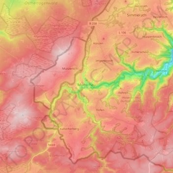
Monschau topographic map

Click on the map to display elevation.

Monschau

At two meetings in the spring meet canoeists for about 50 years in Monschau international events, and a whitewater races. Nationally known is the Monschau Marathon more than 760 meters of altitude, which takes place in August.

Wikipedia (CC-BY-SA 3.0)

About this map

Name: Monschau topographic map, elevation, terrain.

Location: Monschau, Aachen (district), North Rhine-Westphalia, 52156, Germany (50.49435 6.17407 50.61171 6.38020)

Average elevation: 551 m

Minimum elevation: 307 m

Maximum elevation: 670 m

Other topographic maps

Click on a map to view its topography, its elevation and its terrain.
Gear up for your next adventure:

🔦LED Camping Lanterns - Illumination for reading maps inside your tent at night
📦Dry Bags - Waterproof bags to protect gear from rain
🚲Bikepacking Frame Bags - Storage for tools and navigation gear on long off-road rides
🕶️Polarized Sunglasses - Reduces glare from snow and water when reading terrain
🧺Mesh Stuff Sacks - Breathable storage for wet gear or camp organization

As an Amazon Associate, this site earns from qualifying purchases at no extra cost to you.