Geolocate

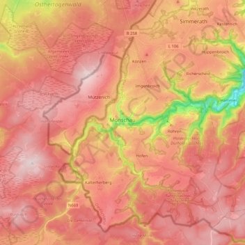
Monschau topographic map

Click on the map to display elevation.

Monschau

At two meetings in the spring meet canoeists for about 50 years in Monschau international events, and a whitewater races. Nationally known is the Monschau Marathon more than 760 meters of altitude, which takes place in August.

Wikipedia (CC-BY-SA 3.0)

About this map

Name: Monschau topographic map, elevation, terrain.

Location: Monschau, Aachen (district), North Rhine-Westphalia, 52156, Germany (50.49435 6.17407 50.61171 6.38020)

Average elevation: 551 m

Minimum elevation: 307 m

Maximum elevation: 670 m

Other topographic maps

Click on a map to view its topography, its elevation and its terrain.
Gear up for your next adventure:

🎒Backpack Rain Covers - Universal waterproof covers to protect your gear from downpours
🌂Windproof Trekking Umbrellas - Surprising but effective rain protection on low-wind trails
💧Hydration Reservoirs - Convenient water bladders for hands-free drinking on the move
🌄Outdoor Binoculars - Compact binoculars for landscape observation
🧼Technical Clothing Wash - Special soap to clean and restore waterproof membranes

As an Amazon Associate, this site earns from qualifying purchases at no extra cost to you.