Geolocate

Quepem topographic map

Click on the map to display elevation.

Quepem

Quepem has an average elevation of 21 metres (69 feet). It is located on the bank of River Kushawati. Curchorem and Sanvordem are the major towns located near the Quepem town.

Wikipedia (CC-BY-SA 3.0)

About this map

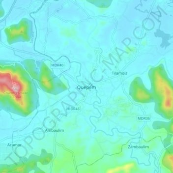
Name: Quepem topographic map, elevation, terrain.

Location: Quepem, South Goa District, Goa, 403705, India (15.17425 74.03078 15.25425 74.11078)

Average elevation: 41 m

Minimum elevation: 0 m

Maximum elevation: 338 m

Gear up for your next adventure:

🔥Emergency Fire Starters - Reliable ignition tools for survival situations in damp conditions
🚲Bikepacking Frame Bags - Storage for tools and navigation gear on long off-road rides
📢Survival Whistles - Essential safety gear for signaling for help in mountain fog
🛌Sleeping Mats - Insulated mats for comfortable outdoor sleeping
🧣Fleece Neck Warmers - Extra insulation for winter topographic surveys

As an Amazon Associate, this site earns from qualifying purchases at no extra cost to you.