
Thank you for supporting this site ❤️
Make a donation
Make a donation
Gear up for your next adventure:
As an Amazon Associate, this site earns from qualifying purchases at no extra cost to you.
Arabi topographic map
Click on the map to display elevation.
Thank you for supporting this site ❤️
Make a donation
Make a donation
Gear up for your next adventure:
As an Amazon Associate, this site earns from qualifying purchases at no extra cost to you.
About this map
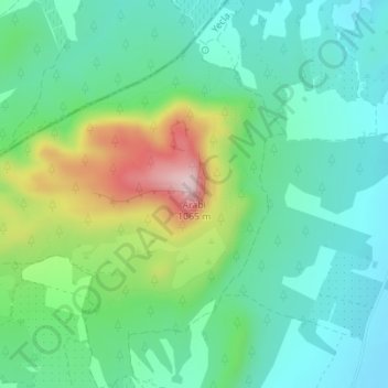
Name: Arabi topographic map, elevation, terrain.
Location: Arabi, Yecla, Altiplano, Region of Murcia, Spain (38.69721 -1.28282 38.69731 -1.28272)
Average elevation: 822 m
Minimum elevation: 733 m
Maximum elevation: 1,046 m
Thank you for supporting this site ❤️
Make a donation
Make a donation
Gear up for your next adventure:
As an Amazon Associate, this site earns from qualifying purchases at no extra cost to you.