
Καστανιά topographic map
Interactive map
Click on the map to display elevation.
About this map
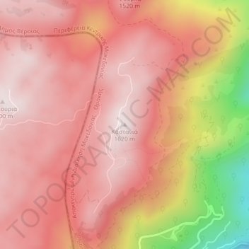
Name: Καστανιά topographic map, elevation, terrain.
Average elevation: 1,434 m
Minimum elevation: 970 m
Maximum elevation: 1,619 m
Other topographic maps
Click on a map to view its topography, its elevation and its terrain.
Vergina
Greece > Macedonia and Thrace > Imathia Regional Unit > Veria Municipality
Average elevation: 141 m