
Jerrabomberra topographic map
Interactive map
Click on the map to display elevation.
About this map
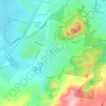
Name: Jerrabomberra topographic map, elevation, terrain.
Average elevation: 646 m
Minimum elevation: 572 m
Maximum elevation: 821 m
Other topographic maps
Click on a map to view its topography, its elevation and its terrain.
Queanbeyan
Australia > New South Wales > Queanbeyan
Bungendore, Queanbeyan, Queanbeyan-Palerang Regional Council, New South Wales, 2621, Australia
Average elevation: 798 m
Lowden
Australia > New South Wales > Queanbeyan
Lowden, Queanbeyan, Queanbeyan-Palerang Regional Council, New South Wales, Australia
Average elevation: 1,136 m