
Make a donation
Gear up for your next adventure:
As an Amazon Associate, this site earns from qualifying purchases at no extra cost to you.
Terlet topographic map
Click on the map to display elevation.
Make a donation
Gear up for your next adventure:
As an Amazon Associate, this site earns from qualifying purchases at no extra cost to you.
About this map
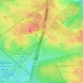
Name: Terlet topographic map, elevation, terrain.
Location: Terlet, Arnhem, Gelderland, Nederland, 6891 ZZ, Nederland (52.03897 5.92129 52.07897 5.96129)
Average elevation: 75 m
Minimum elevation: 47 m
Maximum elevation: 103 m
Make a donation
Gear up for your next adventure:
As an Amazon Associate, this site earns from qualifying purchases at no extra cost to you.
Other topographic maps
Click on a map to view its topography, its elevation and its terrain.
Make a donation
Gear up for your next adventure:
As an Amazon Associate, this site earns from qualifying purchases at no extra cost to you.
Sonsbeek
Nederland > Gelderland > Arnhem
Park Angerenstein · Bronbeek · Gulden Bodem · Hoogte 80 · Immerloopark · Jubileumpark · Park Klarenbeek · Lichtenbeek en Boschveld · Mariëndaal · Stadsblokken-Meinerswijk · Moscowa · Onderlangs · Park Presikhaaf · Park Sonsbeek · Warnsborn · Westerheide · Park Westerveld · Park Zypendaal
Average elevation: 43 m