
Hermeskeil topographic map
Interactive map
Click on the map to display elevation.
About this map
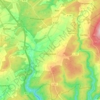
Name: Hermeskeil topographic map, elevation, terrain.
Average elevation: 540 m
Minimum elevation: 405 m
Maximum elevation: 706 m
Die Stadt liegt im Schwarzwälder Hochwald im Südwesten des Hunsrücks. Die Gemarkung erstreckt sich in 500 bis 600 Metern Höhe in einer Mulde des Hochwalds, die den geographischen Mittelpunkt des Naturparks Saar-Hunsrück bildet. Eine Nachbarstadt ist das saarländische Wadern.