
Make a donation
Gear up for your next adventure:
As an Amazon Associate, this site earns from qualifying purchases at no extra cost to you.
La Ressource topographic map
Click on the map to display elevation.
Make a donation
Gear up for your next adventure:
As an Amazon Associate, this site earns from qualifying purchases at no extra cost to you.
About this map
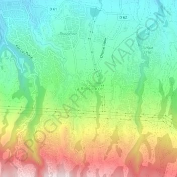
Name: La Ressource topographic map, elevation, terrain.
Average elevation: 342 m
Minimum elevation: 98 m
Maximum elevation: 759 m
Make a donation
Gear up for your next adventure:
As an Amazon Associate, this site earns from qualifying purchases at no extra cost to you.
Other topographic maps
Click on a map to view its topography, its elevation and its terrain.
Terrain Elisa
France > La Réunion > Sainte-Marie
Le Terrain Élisa constitue un quartier de la commune de Sainte-Marie situé au sud du centre-ville à environ 200 mètres d'altitude et compte 2 100 habitants en 2022 ; un PCDT (Projet Citoyen de Développement de Territoire) éc(H)o Village ELISA est mené jusqu'en 2030 par ses habitants : facebook Siège…
Average elevation: 221 m