
Clayhidon topographic map
Interactive map
Click on the map to display elevation.
About this map
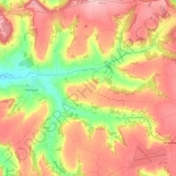
Name: Clayhidon topographic map, elevation, terrain.
Location: Clayhidon, Mid Devon, Devon, England, United Kingdom (50.87708 -3.21549 50.94867 -3.14236)
Average elevation: 212 m
Minimum elevation: 111 m
Maximum elevation: 282 m
Devon trails, hiking, mountain biking, running and outdoor activities
Other topographic maps
Click on a map to view its topography, its elevation and its terrain.
Wordland Cross
United Kingdom > England > Devon > Mid Devon > Cheriton Fitzpaine
Average elevation: 120 m