
Thank you for supporting this site ❤️
Make a donation
Make a donation
Gear up for your next adventure:
As an Amazon Associate, this site earns from qualifying purchases at no extra cost to you.
Eichenbühl topographic map
Click on the map to display elevation.
Thank you for supporting this site ❤️
Make a donation
Make a donation
Gear up for your next adventure:
As an Amazon Associate, this site earns from qualifying purchases at no extra cost to you.
About this map
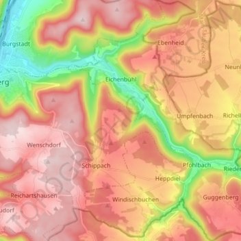
Name: Eichenbühl topographic map, elevation, terrain.
Location: Eichenbühl, Landkreis Miltenberg, Bavaria, 63928, Germany (49.64278 9.30126 49.73195 9.41948)
Average elevation: 336 m
Minimum elevation: 123 m
Maximum elevation: 486 m
Thank you for supporting this site ❤️
Make a donation
Make a donation
Gear up for your next adventure:
As an Amazon Associate, this site earns from qualifying purchases at no extra cost to you.
Other topographic maps
Click on a map to view its topography, its elevation and its terrain.
Miltenberg
Germany > Bavaria > Landkreis Miltenberg > Miltenberg > Miltenberg
Average elevation: 279 m