
Cedar Vale topographic map
Interactive map
Click on the map to display elevation.
About this map
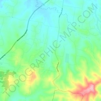
Name: Cedar Vale topographic map, elevation, terrain.
Location: Cedar Vale, Logan City, Queensland, Australie (-27.90254 152.98623 -27.85710 153.04603)
Average elevation: 87 m
Minimum elevation: 28 m
Maximum elevation: 233 m
Other topographic maps
Click on a map to view its topography, its elevation and its terrain.
Logan City
Australie > Queensland > Logan City
Logan City, Queensland, Australie
Average elevation: 61 m