Geolocate

Valloux topographic map

Click on the map to display elevation.

About this map
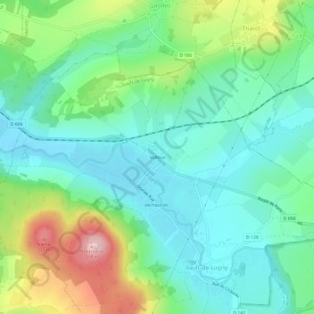
Name: Valloux topographic map, elevation, terrain.

Location: Valloux, Vault-de-Lugny, Avallon, Yonne, Bourgogne-Franche-Comté, France métropolitaine, 89200, France (47.49208 3.82083 47.53208 3.86083)

Average elevation: 199 m

Minimum elevation: 137 m

Maximum elevation: 350 m

Other topographic maps

Click on a map to view its topography, its elevation and its terrain.

Le Cousin

France > Bourgogne-Franche-Comté > Yonne > Vault-de-Lugny > Vermoiron

Le Cousin prend sa source à cheval sur les départements de la Nièvre et de la Côte d'Or, à 610 m d'altitude, à environ 400 m à l'est du carrefour de la Chapelle (croisement de la D 229 avec la D 20).

Average elevation: 186 m

Gear up for your next adventure:

🧦Merino Wool Hiking Socks - Moisture-wicking socks to prevent blisters during long mountain walks
🧤Thermal Touchscreen Gloves - Stay warm while operating your GPS or smartphone camera
📚UK Hiking Guidebooks - Detailed route descriptions for the Lake District, Peaks, and Highlands
📻Hand-Crank Emergency Radios - Stay updated on weather warnings in remote areas
🍳Camping Stoves - Compact stoves for outdoor cooking

As an Amazon Associate, this site earns from qualifying purchases at no extra cost to you.