
North Stonington topographic map
Interactive map
Click on the map to display elevation.
About this map
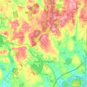
Name: North Stonington topographic map, elevation, terrain.
Average elevation: 78 m
Minimum elevation: 3 m
Maximum elevation: 163 m
Other topographic maps
Click on a map to view its topography, its elevation and its terrain.
Mashantucket
United States > Connecticut > New London County > Ledyard > Mashantucket
Mashantucket, Ledyard, New London County, Connecticut, United States
Average elevation: 65 m
Colchester
United States > Connecticut > New London County > Colchester
Colchester, New London County, Connecticut, United States
Average elevation: 132 m
Waterford
United States > Connecticut > New London County > Waterford
Waterford, New London County, Connecticut, 06385, United States
Average elevation: 35 m
Sprague
United States > Connecticut > New London County > Sprague
Sprague, New London County, Connecticut, United States
Average elevation: 77 m
Town Open Space (Roxbury & Romagna Roads)
United States > Connecticut > New London County > East Lyme > Niantic
Town Open Space (Roxbury & Romagna Roads), Niantic, East Lyme, New London County, Connecticut, United States
Average elevation: 26 m
Griswold
United States > Connecticut > New London County > Griswold
Griswold, New London County, Connecticut, United States
Average elevation: 70 m
Poquonock Bridge
United States > Connecticut > New London County > Groton > Poquonock Bridge
Poquonock Bridge, Groton, New London County, Connecticut, United States
Average elevation: 15 m