Geolocate

Leigh topographic map

Click on the map to display elevation.

About this map

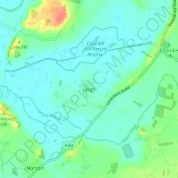
Name: Leigh topographic map, elevation, terrain.

Location: Leigh, Tewkesbury, Gloucestershire, England, GL19 4AG, United Kingdom (51.91300 -2.20971 51.95300 -2.16971)

Average elevation: 17 m

Minimum elevation: 6 m

Maximum elevation: 53 m

Gloucestershire trails, hiking, mountain biking, running and outdoor activities

Other topographic maps

Click on a map to view its topography, its elevation and its terrain.

Tirley

United Kingdom > England > Gloucestershire > Tewkesbury

Average elevation: 19 m

Gear up for your next adventure:

🧥Softshell Jackets - Breathable jackets for active outdoor use
👖Convertible Hiking Trousers - Versatile zip-off pants for changing mountain weather conditions
🥤Collapsible Water Bottles - Save space in your rucksack as you consume your water
🧥Breathable Waterproof Jackets - Essential rain protection for the unpredictable British climate
🛌Insulated Sleeping Mats - Crucial thermal protection when sleeping on cold, uneven ground

As an Amazon Associate, this site earns from qualifying purchases at no extra cost to you.