Geolocate

Redisham topographic map

Click on the map to display elevation.

About this map

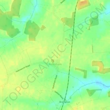
Name: Redisham topographic map, elevation, terrain.

Location: Redisham, East Suffolk, Suffolk, England, United Kingdom (52.39422 1.51775 52.41849 1.54740)

Average elevation: 35 m

Minimum elevation: 20 m

Maximum elevation: 46 m

Suffolk trails, hiking, mountain biking, running and outdoor activities

Other topographic maps

Click on a map to view its topography, its elevation and its terrain.

Hulver Street

United Kingdom > England > Suffolk > East Suffolk

Average elevation: 16 m

Sibton Green

United Kingdom > England > Suffolk > East Suffolk

Average elevation: 35 m

Sweffling

United Kingdom > England > Suffolk > East Suffolk

Average elevation: 32 m

Thorpeness

United Kingdom > England > Suffolk > East Suffolk

Average elevation: 4 m

Benhall Green

United Kingdom > England > Suffolk > East Suffolk

Average elevation: 21 m

Henstead

United Kingdom > England > Suffolk > East Suffolk

Average elevation: 13 m

Somerleyton

United Kingdom > England > Suffolk > East Suffolk

Average elevation: 9 m

Butley Abbey

United Kingdom > England > Suffolk > East Suffolk > Butley

Average elevation: 9 m

Hinton

United Kingdom > England > Suffolk > East Suffolk > Blythburgh

Average elevation: 19 m

Kelsale

United Kingdom > England > Suffolk > East Suffolk

Average elevation: 32 m

Wangford

United Kingdom > England > Suffolk > East Suffolk

Average elevation: 13 m

Wenhaston

United Kingdom > England > Suffolk > East Suffolk

Average elevation: 16 m

Sizewell

United Kingdom > England > Suffolk > East Suffolk > Leiston

Average elevation: 5 m

Wangford

United Kingdom > England > Suffolk > East Suffolk

Average elevation: 13 m

Wangford

United Kingdom > England > Suffolk > East Suffolk

Average elevation: 13 m

Sweffling

United Kingdom > England > Suffolk > East Suffolk

Average elevation: 32 m

Sizewell

United Kingdom > England > Suffolk > East Suffolk > Leiston

Average elevation: 5 m

Gear up for your next adventure:

📍Handheld GPS Navigators - Reliable satellite navigation for hiking and off-road exploration
🎒Hiking Daypacks (20L) - Compact backpacks for day trips and technical mountain ascents
👟Men's Trail Running Shoes - Lightweight grip for fast movement over topographic contours
🧢Waterproof Hiking Hats - Keep the rain off your face while studying topographic maps
🧤Hiking Gloves - Warm and durable gloves for cold-weather walks

As an Amazon Associate, this site earns from qualifying purchases at no extra cost to you.