Geolocate

Forno di Zoldo topographic map

Interactive map

Click on the map to display elevation.

About this map

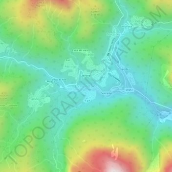
Name: Forno di Zoldo topographic map, elevation, terrain.

Location: Forno di Zoldo, Val di Zoldo, Belluno, Veneto, 32012, Italy (46.32662 12.15709 46.36662 12.19709)

Average elevation: 1,126 m

Minimum elevation: 794 m

Maximum elevation: 1,907 m

Other topographic maps

Click on a map to view its topography, its elevation and its terrain.

Nele

Italy > Veneto > Belluno > Agordo

Average elevation: 1,421 m

Calalzo di Cadore

Italy > Veneto > Belluno

Average elevation: 1,396 m

Lamon

Italy > Veneto > Belluno

Average elevation: 961 m

Cimon del Froppa

Italy > Veneto > Belluno > Auronzo di Cadore

Average elevation: 2,314 m

Alpago

Italy > Veneto > Belluno

Average elevation: 947 m

Rocca Pietore

Italy > Veneto > Belluno

Average elevation: 1,691 m

Termine di Cadore

Italy > Veneto > Belluno > Ospitale di Cadore

Average elevation: 1,043 m

Cibiana di Cadore

Italy > Veneto > Belluno

Average elevation: 1,460 m

Pieve d'Alpago

Italy > Veneto > Belluno

Average elevation: 879 m

Gosaldo

Italy > Veneto > Belluno

Average elevation: 1,433 m

Tiser

Italy > Veneto > Belluno

Average elevation: 1,180 m

Alleghe

Italy > Veneto > Belluno

Average elevation: 1,654 m

Lago di Corlo

Italy > Veneto > Belluno > Rocca d'Arsiè

Average elevation: 592 m

Castion

Italy > Veneto > Belluno > Belluno

Average elevation: 425 m

Santa Croce del Lago

Italy > Veneto > Belluno > Farra d'Alpago

Average elevation: 730 m

Nevegal

Italy > Veneto > Belluno > Belluno

Average elevation: 1,076 m

Sarasin

Italy > Veneto > Belluno

Average elevation: 1,266 m

Borgo Valbelluna

Italy > Veneto > Belluno

Average elevation: 578 m

Sedico

Italy > Veneto > Belluno

Average elevation: 930 m

Colle Santa Lucia

Italy > Veneto > Belluno

Average elevation: 1,728 m

Cortina d'Ampezzo

Italy > Veneto > Belluno

Among the surrounding mountains are Tofane to the west, Pomagagnon to the north, Cristallo to the northeast, Faloria and Sorapiss to the east, and Becco di Mezzodì, Croda da Lago and Cinque Torri to the south. Monte Antelao (Nantelou in Ladin) is at 3264 m the highest mountain in the Ampezzo Dolomites and the…

Average elevation: 1,974 m

Valparola Pass

Italy > Veneto > Belluno

Average elevation: 2,199 m

Falzarego Pass

Italy > Veneto > Belluno > Cortina d'Ampezzo

Average elevation: 2,179 m

Fonzaso

Italy > Veneto > Belluno

Average elevation: 629 m

Selva di Cadore

Italy > Veneto > Belluno

Average elevation: 1,696 m

Misurina

Italy > Veneto > Belluno > Auronzo di Cadore

Average elevation: 1,954 m

Monte Piana

Italy > Veneto > Belluno > Auronzo di Cadore

Average elevation: 1,850 m

Tre Cime di Lavaredo - Drei Zinnen

Italy > Veneto > Belluno > Auronzo di Cadore

Until 1919 the peaks formed part of the border between Italy and Austria-Hungary. Now they lie on the border between the Italian provinces of South Tyrol and Belluno and still are a part of the linguistic boundary between German-speaking and Italian-speaking majorities. The Cima Grande has an elevation of…

Average elevation: 2,242 m

Sospirolo

Italy > Veneto > Belluno

Average elevation: 912 m

Rasai

Italy > Veneto > Belluno

Average elevation: 434 m

Pocol

Italy > Veneto > Belluno > Cortina d'Ampezzo

Average elevation: 1,448 m

Marmolada

Italy > Veneto > Belluno

The ridge is composed of several summits, decreasing in altitude from west to east: Punta Penia 3,343 metres (10,968 ft), Punta Rocca 3,309 metres (10,856 ft), Punta Ombretta 3,230 metres (10,600 ft), Monte Serauta 3,069 metres (10,069 ft), and Pizzo Serauta 3,035 metres (9,957 ft). An aerial tramway goes to…

Average elevation: 1,896 m

La Sega

Italy > Veneto > Belluno > Feltre

Average elevation: 314 m

Ponte nelle Alpi

Italy > Veneto > Belluno

Average elevation: 739 m

Frassené

Italy > Veneto > Belluno > Frassené

Average elevation: 536 m

Nono

Italy > Veneto > Belluno > Longarone

Average elevation: 1,377 m

Mel

Italy > Veneto > Belluno

Average elevation: 598 m

Gruppo del Pomagagnon

Italy > Veneto > Belluno > Cortina d'Ampezzo

Pomagagnon is a mountain of the Dolomites in Belluno, northern Italy. It has an elevation of 2,450 metres (8,038 ft) and is the southernmost mountain of the Cristallo Group, towering 1,200 metres (3,937 ft) over the resort of Cortina d'Ampezzo. The mountain is part of the "Natural Park of the Ampezzo…

Average elevation: 1,758 m

Pieve di Cadore

Italy > Veneto > Belluno > Pieve di Cadore > Pieve di Cadore

Average elevation: 1,116 m

Auric

Italy > Veneto > Belluno > Mellame > Sassei

Average elevation: 403 m

Pedavena

Italy > Veneto > Belluno

Average elevation: 595 m

Agordo

Italy > Veneto > Belluno

Average elevation: 1,292 m

Falcade

Italy > Veneto > Belluno

Average elevation: 1,928 m

Mottes

Italy > Veneto > Belluno > Rivamonte Agordino > Rivamonte Agordino

Average elevation: 994 m

Feltre

Italy > Veneto > Belluno

Average elevation: 753 m

Cinque Torri

Italy > Veneto > Belluno > Cortina d'Ampezzo

Average elevation: 2,071 m

Grigna

Italy > Veneto > Belluno > Auronzo di Cadore

Average elevation: 1,507 m