Geolocate

Oberdorf (SO) topographic map

Interactive map

Click on the map to display elevation.

About this map

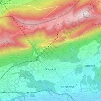
Name: Oberdorf (SO) topographic map, elevation, terrain.

Location: Oberdorf (SO), Bezirk Lebern, Amtei Solothurn-Lebern, Solothurn, 4515, Switzerland (47.22031 7.45297 47.25764 7.52563)

Average elevation: 805 m

Minimum elevation: 449 m

Maximum elevation: 1,392 m

Other topographic maps

Click on a map to view its topography, its elevation and its terrain.

Grenchen

Switzerland > Solothurn > Amtei Solothurn-Lebern

The municipality is the capital of the Lebern District. It is the second largest city in the Canton of Solothurn. The municipality stretches from the hamlet of Staad along the Aare river, (at an elevation of 430 m (1,410 ft)) to the first mountain range of the Jura Mountains (the Oberer Grenchenberg is 1,348 m…

Average elevation: 705 m