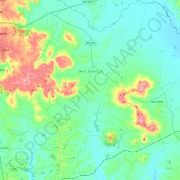
Passo do Sobrado topographic map
Interactive map
Click on the map to display elevation.
About this map
Other topographic maps
Click on a map to view its topography, its elevation and its terrain.
Glória
Brazil > Rio Grande do Sul > Metropolitan Region of Porto Alegre > Porto Alegre
Average elevation: 117 m
Eldorado do Sul
Brazil > Rio Grande do Sul > Metropolitan Region of Porto Alegre
Average elevation: 27 m
Itapuã
Brazil > Rio Grande do Sul > Metropolitan Region of Porto Alegre > Viamão
Average elevation: 20 m
Guaporé
Guaporé is located on the Serra Gaúcha a mountainous area of the north-eastern Rio Grande do Sul. The city center is at an altitude of 478 m above sea level, although some peaks reach the 700 m mark. It is situated between the highlands of the Planalto and lowlands of the Depressão Central and is composed…
Average elevation: 470 m
Quaraí
Quarai is a Brazilian municipality located near the border with Uruguay on the Rio Quaraí. The population is 22,607 (2020 est.) in an area of 3,147.63 km2, making it one of the largest municipalities in the state. Its elevation is 112 m. It is located 590 km west of the state capital of Porto Alegre,…
Average elevation: 150 m
Porto Alegre
Brazil > Rio Grande do Sul > Metropolitan Region of Porto Alegre
Porto Alegre has a long coastline on the Guaíba Lake, and its topography is punctuated by 40 hills. In the lake, a vast body of water, a maze of islands facing the city creates an archipelago where a unique ecosystem gives shelter to abundant wildlife. The city area concentrates 28% of the native flora of Rio…
Average elevation: 26 m
Porto Alegre
Brazil > Rio Grande do Sul > Metropolitan Region of Porto Alegre > Porto Alegre
Porto Alegre has a long coastline on the Guaíba Lake, and its topography is punctuated by 40 hills. In the lake, a vast body of water, a maze of islands facing the city creates an archipelago where a unique ecosystem gives shelter to abundant wildlife. The city area concentrates 28% of the native flora of Rio…
Average elevation: 27 m
Itaqui
Itaqui is a municipality in Brazil, located in the southwestern part of the state of Rio Grande do Sul, close to the Argentinian border, between Uruguaiana and São Borja. It sits at a mean altitude of 57 meters (187 ft), by the Uruguay River. Its population is currently estimated at 37,489.
Average elevation: 70 m
São Francisco de Assis
São Francisco de Assis is a Brazilian municipality in the western part of the state of Rio Grande do Sul. It has a population of 18,205 (2020). Its elevation is 151 m. It has an area of 2,530.9 km². It is located 434 km west of the state capital of Porto Alegre. The nickname of the city is Sao Chico.
Average elevation: 189 m
Rio Pardo
Rio Pardo is a municipality in the state of Rio Grande do Sul in Brazil. The population is 38,265 (2020 est.) in an area of 2051 km². The elevation is 41 m.
Average elevation: 70 m
Júlio de Castilhos
Júlio de Castilhos is a municipality of the central part of the state of Rio Grande do Sul, Brazil. The population is 19,224 (2020 est.) in an area of 1,929.38 km². Its elevation is 529 m (Praça "João Vieira de Alvarenga"), 516 m at the meteorological station and 503.81 m at the railway station. It is…
Average elevation: 379 m
Nova Bassano
Nova Bassano is situated in the state's mountainous Serra Gaúcha region. It is situated at 28°47′2″S 51°36′36″W / 28.78389°S 51.61000°W / -28.78389; -51.61000, at an altitude of 563 meters above sea level. It occupies an area of 211.612 km².
Average elevation: 629 m
Rosário do Sul
Rosário do Sul is a Brazilian municipality in the southwestern part of the state of Rio Grande do Sul. The population is 39,314 (2020 est.) in an area of 4,369.65 km². Its elevation is 151 m. It is located 385 km west of the state capital of Porto Alegre. Its main industry is agriculture. Many Argentine and…
Average elevation: 141 m