
Illertissen topographic map
Interactive map
Click on the map to display elevation.
About this map
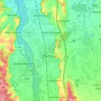
Name: Illertissen topographic map, elevation, terrain.
Location: Illertissen, Landkreis Neu-Ulm, Bavaria, 89257, Germany (48.18379 10.06622 48.26941 10.15360)
Average elevation: 522 m
Minimum elevation: 493 m
Maximum elevation: 599 m
Other topographic maps
Click on a map to view its topography, its elevation and its terrain.
Kellmünz an der Iller
Germany > Bavaria > Landkreis Neu-Ulm > Kellmünz a.d.Iller
Average elevation: 562 m