Geolocate

Castelbuono topographic map

Click on the map to display elevation.

About this map

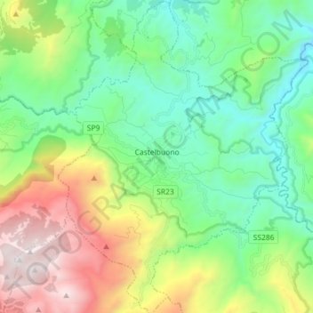
Name: Castelbuono topographic map, elevation, terrain.

Location: Castelbuono, Palermo, Sicily, 90013, Italy (37.87491 14.04275 37.98752 14.15671)

Average elevation: 673 m

Minimum elevation: 67 m

Maximum elevation: 1,976 m

Other topographic maps

Click on a map to view its topography, its elevation and its terrain.

Sorgente di Montescuro

Italy > Sicily > Palermo > Prizzi

Average elevation: 831 m

Bellacera

Italy > Sicily > Palermo > Santa Flavia

Average elevation: 162 m

Finale

Italy > Sicily > Palermo

Average elevation: 84 m

Santa Lucia

Italy > Sicily > Palermo > Cefalù

Average elevation: 51 m

San Carlo

Italy > Sicily > Palermo > Chiusa Sclafani

Average elevation: 291 m

Gear up for your next adventure:

🛌Insulated Sleeping Mats - Crucial thermal protection when sleeping on cold, uneven ground
🥾Walking Shoes - Lightweight walking shoes for countryside and coastal paths
🍲Portable Camping Stoves - Fast-boiling stoves for hot meals on remote topographic survey trips
🥾Hiking Boots - Waterproof and durable boots for long-distance hiking in the UK
🧤Thermal Touchscreen Gloves - Stay warm while operating your GPS or smartphone camera

As an Amazon Associate, this site earns from qualifying purchases at no extra cost to you.