
Russell topographic map
Click on the map to display elevation.
About this map
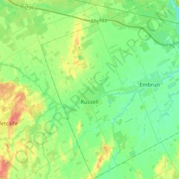
Name: Russell topographic map, elevation, terrain.
Average elevation: 75 m
Minimum elevation: 62 m
Maximum elevation: 104 m
Other topographic maps
Click on a map to view its topography, its elevation and its terrain.
Lefaivre
Canada > Ontario > Prescott and Russell Counties > Alfred and Plantagenet
Average elevation: 50 m
Chute-à-Blondeau
Canada > Ontario > Prescott and Russell Counties > East Hawkesbury
Average elevation: 56 m
Saint-Eugène
Canada > Ontario > Prescott and Russell Counties > East Hawkesbury
Average elevation: 59 m
Clarence Point
Canada > Ontario > Prescott and Russell Counties > Clarence-Rockland > Clarence Point
Average elevation: 61 m
Fournier
Canada > Ontario > Prescott and Russell Counties > The Nation > Fournier
Average elevation: 57 m
Clarence Creek
Canada > Ontario > Prescott and Russell Counties > Clarence-Rockland
Average elevation: 66 m
Saint Pascal Baylon
Canada > Ontario > Prescott and Russell Counties > Clarence-Rockland
Average elevation: 62 m
Alfred
Canada > Ontario > Prescott and Russell Counties > Alfred and Plantagenet
Average elevation: 64 m
St. Albert
Canada > Ontario > Prescott and Russell Counties > The Nation > St. Albert
Average elevation: 66 m
Alfred
Canada > Ontario > Prescott and Russell Counties > Alfred and Plantagenet
Average elevation: 64 m
Caledonia Springs
Canada > Ontario > Prescott and Russell Counties > The Nation
Average elevation: 51 m
Saint-Eugène
Canada > Ontario > Prescott and Russell Counties > East Hawkesbury
Average elevation: 59 m