Geolocate

Trellech topographic map

Click on the map to display elevation.

About this map

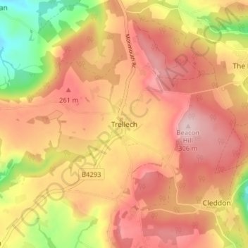
Name: Trellech topographic map, elevation, terrain.

Location: Trellech, Monmouthshire, Wales, NP25 4NY, United Kingdom (51.72509 -2.74445 51.76509 -2.70445)

Average elevation: 217 m

Minimum elevation: 79 m

Maximum elevation: 303 m

Monmouthshire trails, hiking, mountain biking, running and outdoor activities

Other topographic maps

Click on a map to view its topography, its elevation and its terrain.

Llanbadoc

United Kingdom > Wales > Monmouthshire

Average elevation: 78 m

Wye Valley

United Kingdom > Wales > Monmouthshire

Average elevation: 167 m

Penallt

United Kingdom > Wales > Monmouthshire

Average elevation: 174 m

Crucorney

United Kingdom > Wales > Monmouthshire

Average elevation: 297 m

Blorenge

United Kingdom > Wales > Monmouthshire > Govilon

Average elevation: 394 m

River Monnow

United Kingdom > Wales > Monmouthshire

Average elevation: 172 m

River Monnow

United Kingdom > Wales > Monmouthshire

Average elevation: 172 m

Raglan Castle

United Kingdom > Wales > Monmouthshire > Raglan

Average elevation: 59 m

Gear up for your next adventure:

🍲Portable Camping Stoves - Fast-boiling stoves for hot meals on remote topographic survey trips
🛌Sleeping Mats - Insulated mats for comfortable outdoor sleeping
🧤Waterproof Overmitts - Extreme weather protection for hikers and mountaineers
📍Handheld GPS Navigators - Reliable satellite navigation for hiking and off-road exploration
🥾Hiking Boots - Waterproof and durable boots for long-distance hiking in the UK

As an Amazon Associate, this site earns from qualifying purchases at no extra cost to you.