
Takoma Park topographic map
Interactive map
Click on the map to display elevation.
About this map
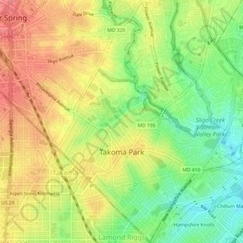
Name: Takoma Park topographic map, elevation, terrain.
Average elevation: 75 m
Minimum elevation: 30 m
Maximum elevation: 116 m
Other topographic maps
Click on a map to view its topography, its elevation and its terrain.
Bethesda
États-Unis d'Amérique > Maryland > Montgomery County
Bethesda, Montgomery County, Maryland, États-Unis d'Amérique
Average elevation: 86 m
Gaithersburg
États-Unis d'Amérique > Maryland > Montgomery County > Gaithersburg
Gaithersburg, Montgomery County, Maryland, États-Unis d'Amérique
Average elevation: 137 m